As longer dry periods during spring and summer become more frequent in Europe, crops more often need irrigation to surpass these periods. This increases the demand for water for agriculture. To cope with this growing demand, the water used for irrigation must be used where it is most needed. Now farmers mostly look at the soil type that is most common on the field to determine the irrigation dose needed for the crop. But it is possible that multiple soil types occur on one field. A different soil texture can lead to a different water retention capacity of the soil, which will lead to a higher or lower need for irrigation. To optimise the water available for irrigation, the irrigation should be adjusted to the need of each soil type of the field.
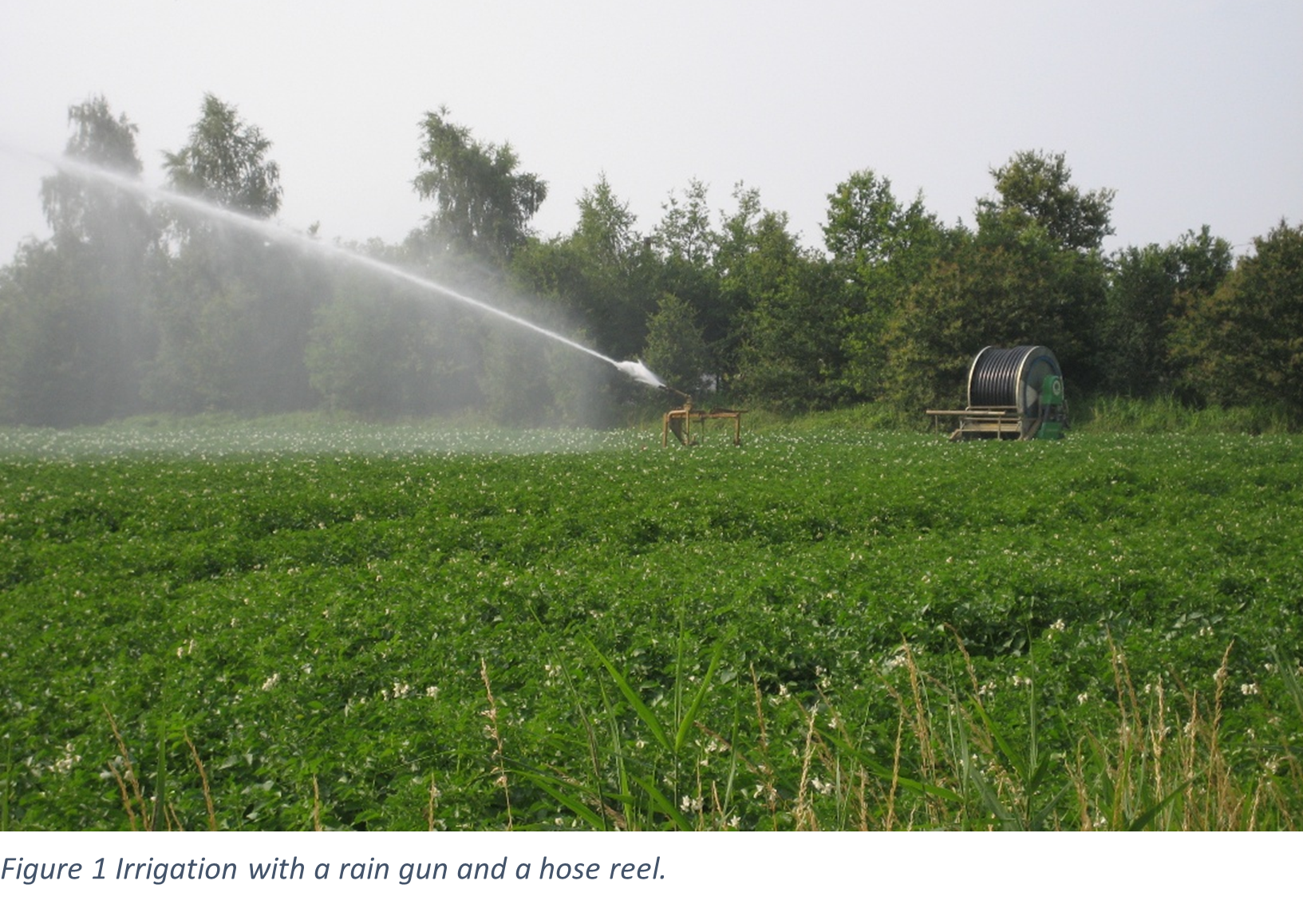
In the Interreg project HydroSoilWise, the Soil Service of Belgium performed a trial to see if adjusted irrigation doses to the soil texture could lead to less irrigation needs but maintain an optimal yield.
To reveal the soil variability, the field was scanned with a soil scanner (Veris MPS3-scanner). Based on these measurements, a soil map was created that indicates the spatial variation within the field. Considering the irrigation equipment of the farmer, the field was divided in two parts:
- A part with a high EC was linked to a higher water retention capacity, this part with more available soil water for the crop should result in less irrigation.
- Another part with a lower EC, and a lower water retention capacity should need more irrigation.
For each part of the field, it was established how much irrigation was needed using a soil water balance model. This model was created by the Soil Service of Belgium and is used to give farmers advice on the scheduling of irrigation. To minimise the workload for the farmers, both parts of the field received irrigation on the same day, but the doses were adjusted to the soil variability. The fields were irrigated with a hose reel and moving gun. The water was spread with a Sime Eleketrorain rain gun. This gun facilitates the farmer to reposition the irrigation gun during the irrigation event.
The fields were scanned before the crops were planted, at the end of
March or beginning of April. The results of the soil scan and the division of
the field according to the results are shown in Figure 2.
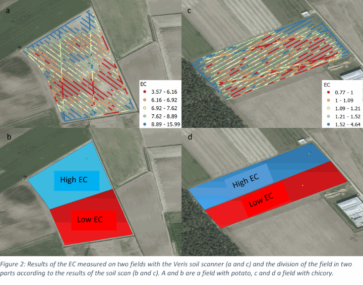
The trial was performed in Belgium, on two fields:
- one with chicory
- one with potato.
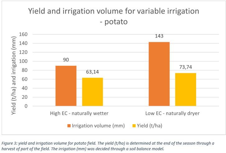
Potato field results
The potato field was irrigated 5 times during the 2025 growing season. The zone with a low EC received 143 mm of irrigation whereas the zone with a high EC only received 90 mm of irrigation. At the end of the season, the yield was determined by harvesting parts of the plot. The zone with a low EC had a higher yield than the zone with a high EC (73 vs 63 t/ha). This means that the zone with a high EC received not enough water to grow to its full potential.
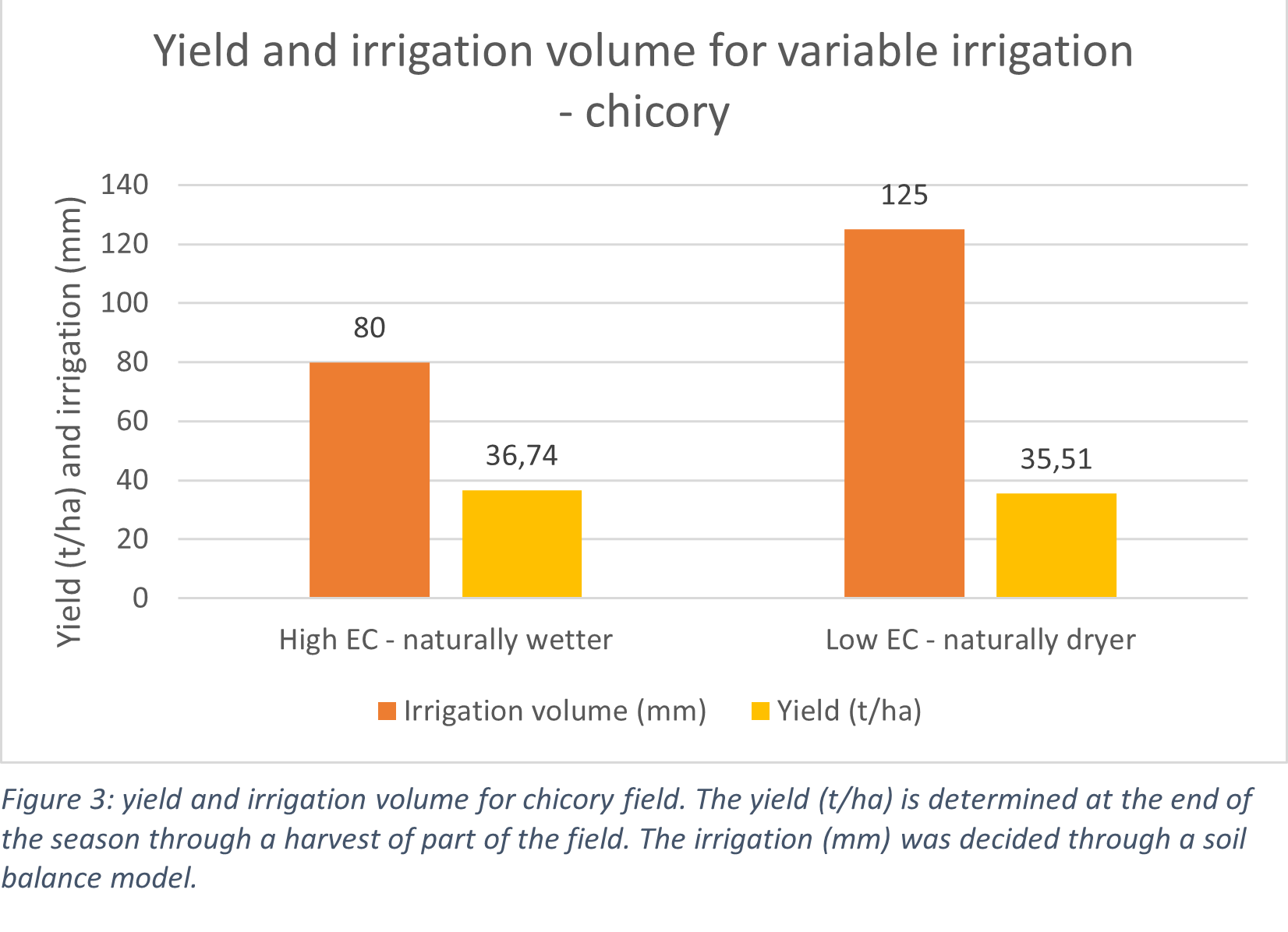
Chicory field results
In the chicory field, the zone with a low EC was irrigated 5 times with in total 125 mm irrigation. The zone with a high EC was irrigated only 4 times with in total 80 mm irrigation. However, their yields were at the end of the season similar (around 35 t/ha). Therefore, we can say we saved 45 mm of irrigation on the zone with a high EC and still obtained an optimal yield.
These trials show us that it is possible to reduce the irrigation on some parts of the field if differences in soil type are known. Through soil scanning, these soil differences can be determined, and by considering the irrigation equipment of the farmer, the field can be divided in different zones. An equal yield can be obtained with less irrigation if the optimal irrigation can be determined. Soil water balance models can be used to calculate the irrigation doses and moments. In 2026, the trials will be repeated on two different fields with similar crops.